
Geographic Information System (GIS) technologies have the capability to revolutionize large-scale electrification planning. Advances in computer-based electrification planning models, satellite imaging, and machine learning are able to optimize infrastructure planning, lowering the costs of electricity provision and expediting progress. Some countries are already taking advantage of these technologies. Yet, their disruptive potential is encumbered by high satellite imagery costs and siloed data sources. Endeavors to collect and share digital resources more widely are in critical need.
GIS IS TWICE AS FAST AND LESS THAN HALF THE COST OF TRADITIONAL METHODS
GIS is Far Superior
- Planning needs to be GIS-based. Relative to traditional electrification master planning, GIS-based approaches are easier to analyze, adapt, visualize, and share. Traditional plans can take two to three years and cost > $2 MM to prepare. In contrast, GIS-based plans for Rwanda and Kenya each cost about $1 MM and took one year.1
- Models make it easier. Computer-based electrification planning models can cut through technical complexity. Given geospatial data inputs, they can automatically prescribe cost-optimal ensembles of electrification modes and detailed system designs at massive scales.2 They are increasing the speeds and reducing the costs of GIS-based planning even further. After obtaining cost-optimal designs, planners can further consider non-technical factors.
Satellites Illuminate the Previously Invisible
- Mapping customers from outer space. Unmapped buildings can be seen from high resolution satellite imagery and these images are becoming more available than ever before. Fleets of larger satellites are expected to launch by 2021, doubling capacities to capture the highest-resolution class of imagery available today.3 Advances in hardware have also enabled the rapid deployment of cheaper small satellites. Over 300 nano/micro-satellites were launched in 2017, representing a 205% increase relative to 2016. This trend is projected to continue: up to 2,600 additional nano/micro-satellites are expected to launch over the next 5 years.4
- Cloud platforms handle big data. Satellite-imaging companies are experimenting with new business models via the cloud to provide a wider range of analytical services.5
Artificial Intelligence Transforms Big Data into Useful Information
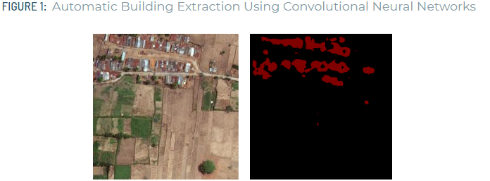
- Automatic infrastructure mapping, courtesy of “the deep learning revolution.” Faster and cheaper computing, along with advances in artificial neural network models, have made it easier than ever for analysts to extract features from satellite imagery (Fig. 1). These methods have already yielded a few publicly available datasets, including new population estimates for developing countries.6
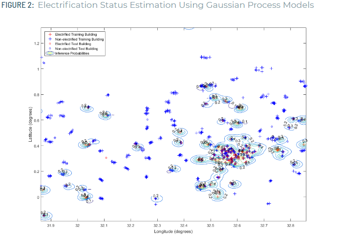
- Machine learning classifies electrification status. Machine learning methods have also been successfully employed for the estimation of current electrification status at the village- and building-levels using survey data (Fig. 2) plus nighttime lighting imagery.7
Savings and benefits are huge if data becomes more accessible
- Better demand forecasting could be a game-changer for rightsizing electrification efforts. A recent study from the MIT-Comillas Universal Energy Access Lab found that planning under different demand assumptions can lead to vast differences in the way systems are built. An electrification model for a representative region of East Africa showed that a low-demand case was nearly 3x more expensive per-unit of electricity than a high-demand case. Optimized system designs and supply characterization also promise profound impact. Given the billions of annual investment in developing region energy systems, the potential value of data-driven planning is enormous.
- Access to data is a significant barrier. Data silos and sluggish data collection endeavors make it challenging for researchers to study electricity access from a systems-level. Furthermore, despite increasing availabilities, a dearth of free satellite imagery and expensive paid imagery make it difficult for budget-constrained development organizations to reap the full benefits of new electrification planning technologies. Making digital resources such as satellite imagery, consumption data, socioeconomic information, and infrastructure data more accessible could empower organizations and expedite progress in building modern energy systems.
Endnotes
- Independent Evaluation Group, “Reliable and Affordable Off-Grid Electricity Services for the Poor: Lessons from the World Bank Group Experience.” Technical report, World Bank (2016).
- The Reference Electrification Model. MIT.
- Spaceflight Now. “DigitalGlobe books two launches with SpaceX for Earth-imaging fleet”
- SpaceWorks Enterprises, Inc., “2018 Nano/Microsatellite Market Forecast, 8th Edition”
- Spaceflight Now. “DigitalGlobe books two launches with SpaceX for Earth-imaging fleet”
- Facebook Connectivity Lab and Center for International Earth Science Information Network – CIESIN – Columbia University. 2016. High Resolution Settlement Layer (HRSL).
- Min, Brian, et al. “Detection of rural electrification in Africa using DMSP-OLS night lights imagery.” International Journal of Remote Sensing 34.22 (2013): 8118-8141.; Lee, Stephen J. “Adaptive Electricity Access Planning.” Massachusetts Institute of Technology (2018).